Where Earth meets the lunar horizon
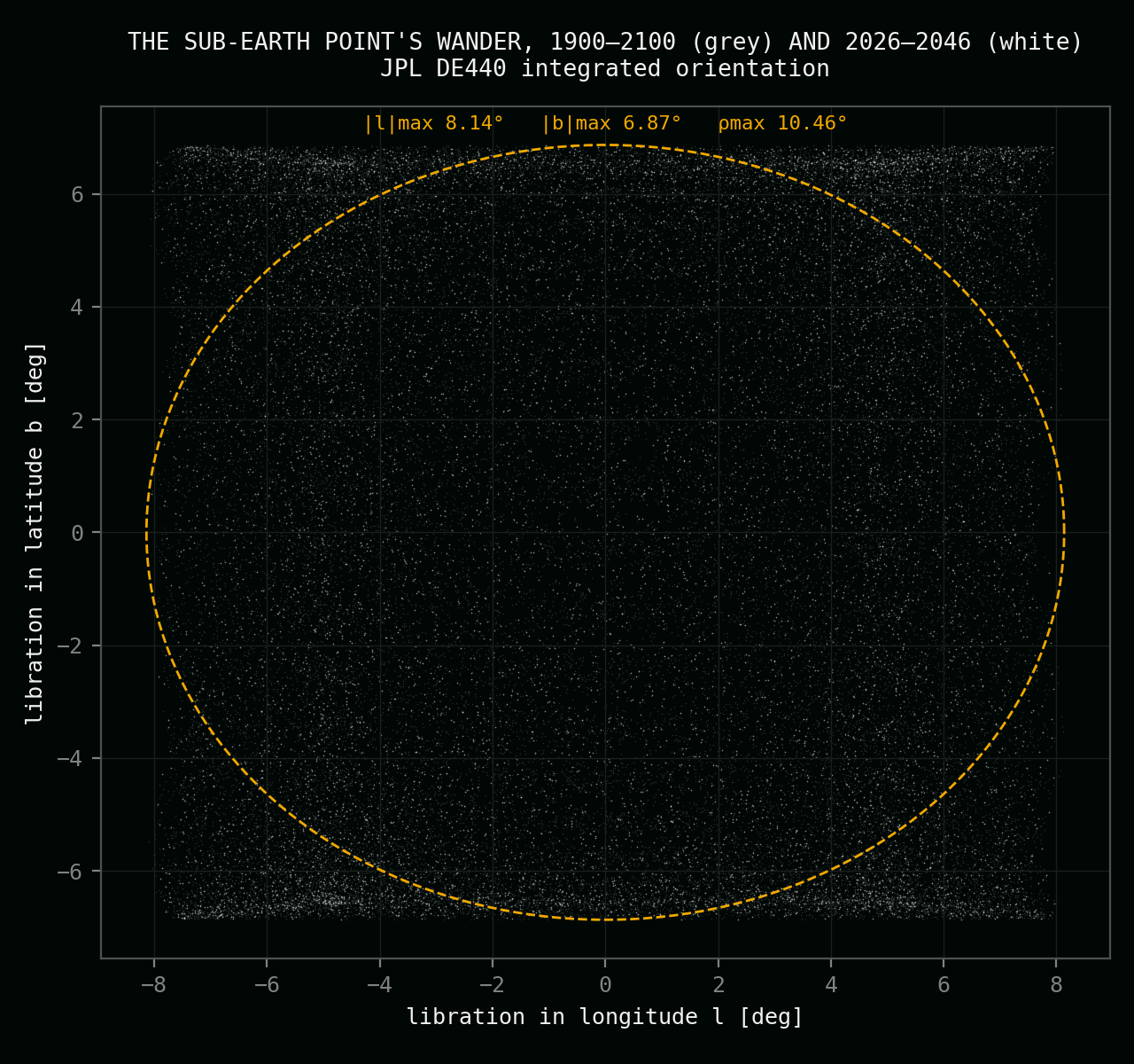
The Moon shows Earth one face, but it does not hold still. A slow wobble — libration — swings Earth's apparent position around a fixed point in the lunar sky, repeating its full pattern every 18.6 years. Where you stand decides what that wobble does to your picture. This project's rule is exact: the horizon may cut deep into Earth's disk — but never past half. Two places on the Moon deliver that, robustly. This page is how they were found.
Three regimes
Three ways to stand on the Moon and watch the Earth
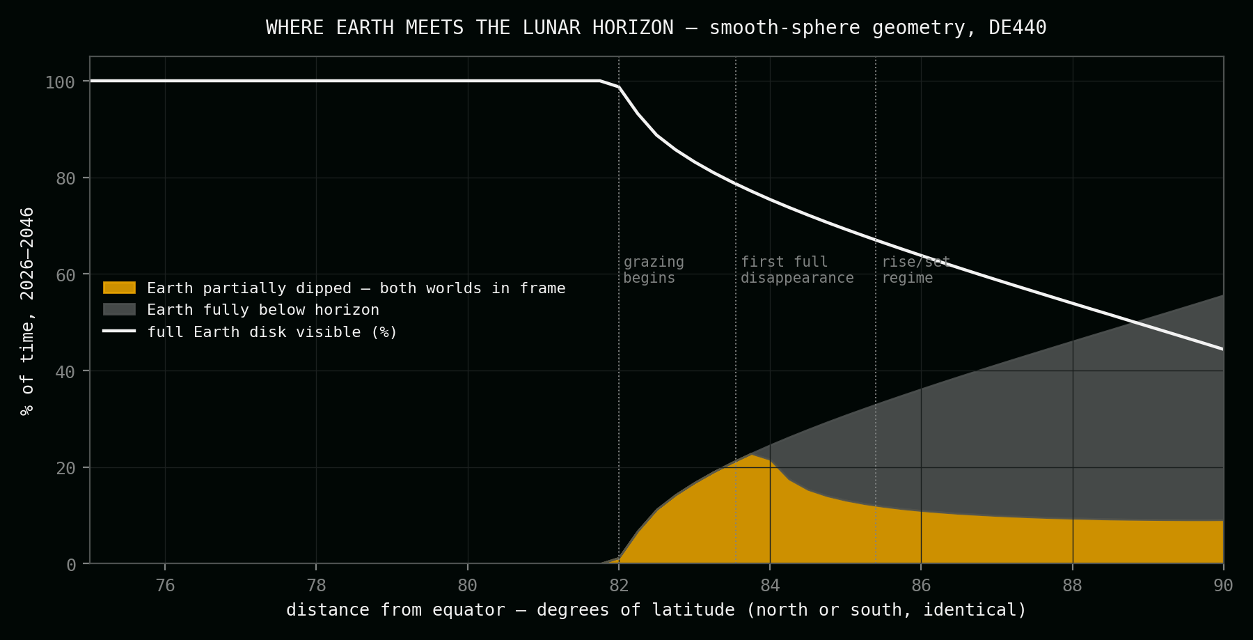
Earth's disk is just 1.8–2.0° wide — about four full Moons — and its entire 18.6-year wander fits inside one fixed picture frame. What changes with latitude is how that frame meets the horizon. The project's brief is the middle case, with a hard bound: Earth and the lunar skyline sharing a single image, and never more than half the planet behind the ground.
The constant portrait
Below about 82° latitude, Earth never touches the horizon. A fixed camera holds the whole planet in frame for decades, drifting gently inside a small patch of sky but never leaving it. Majestic — and motionless.
The bow — both worlds
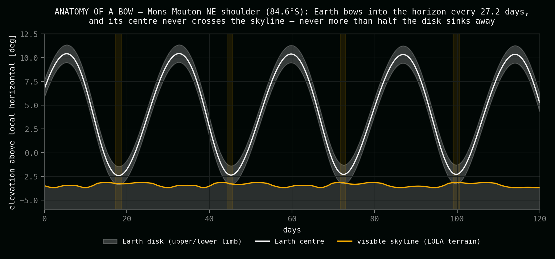
In a narrow band near 83°, and again on high polar ground, the horizon rises into the picture: every 27.21 days Earth bows toward the skyline and the dark lunar ridge bites into the blue disk. At the right sites the bow has a floor — the planet's centre never goes under.
The monthly Earthrise
At the poles themselves, Earth sets completely and returns on a two-week rhythm. No camera on the lunar surface has ever captured it: every Earthrise photograph in history was taken from orbit.
The two sites
A highland in the north, a mountain shoulder in the south
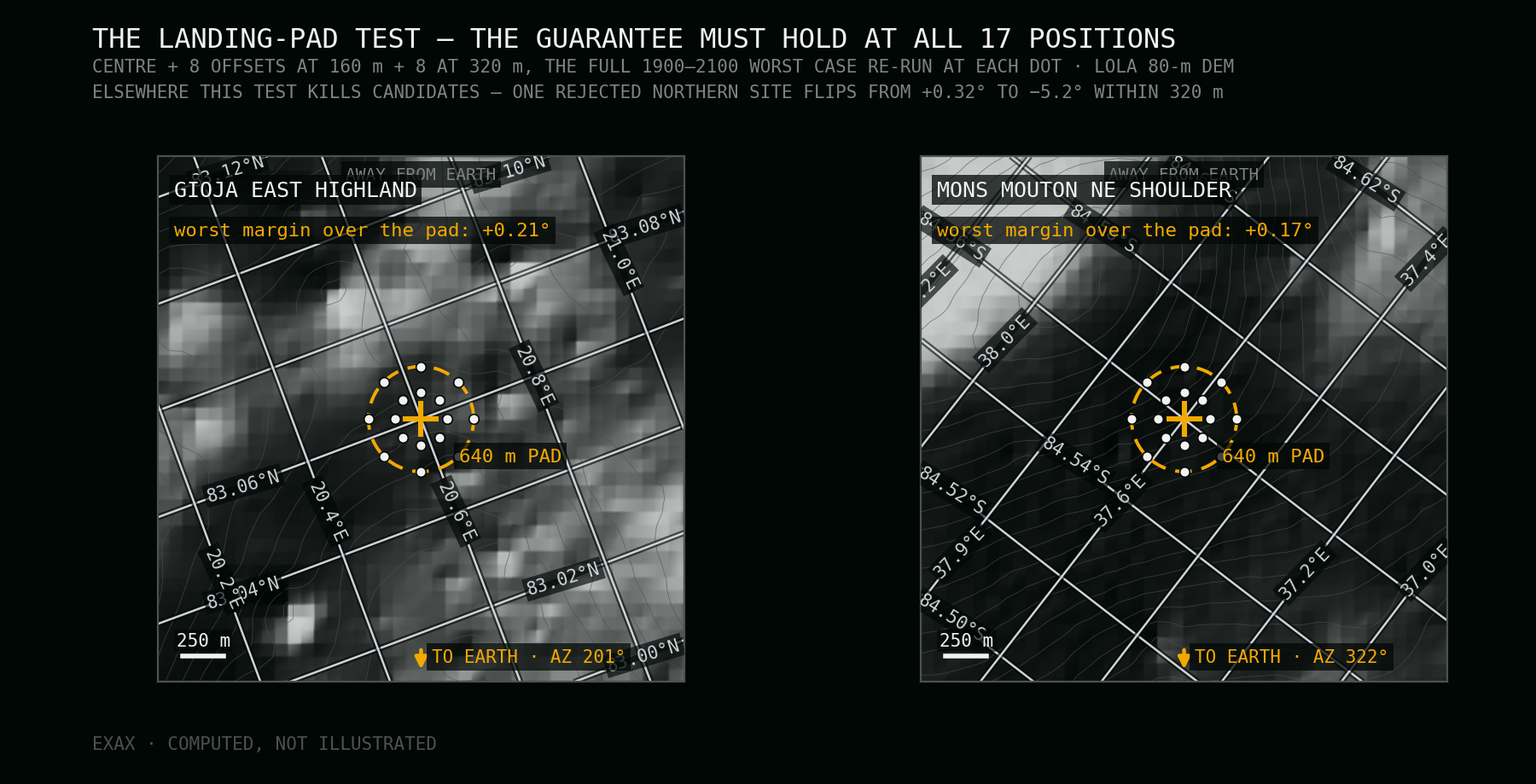
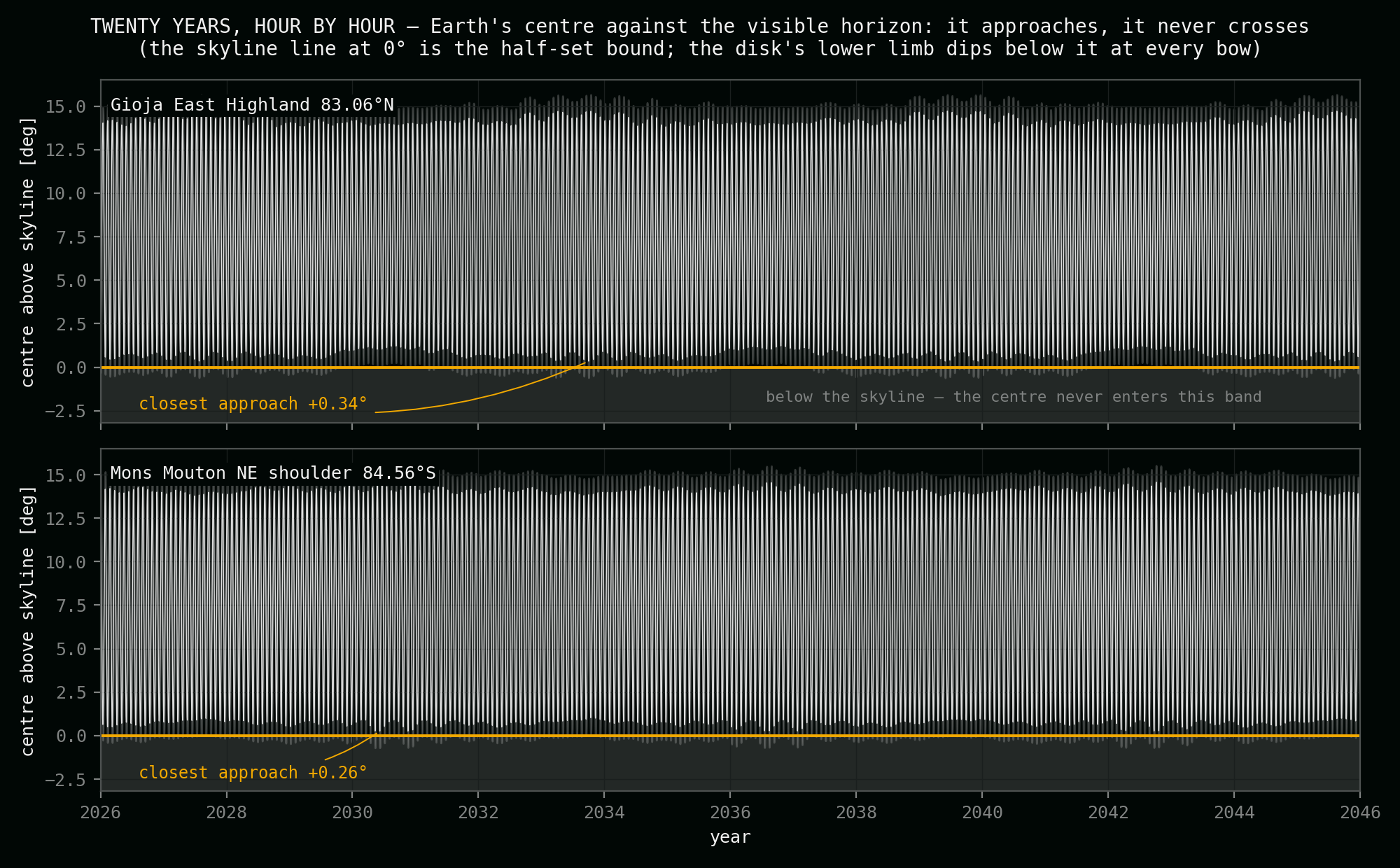
Scoring the entire polar Moon against the half-set rule — exact DE440 sky tracks, hour by hour, against real skylines ray-marched from NASA's laser elevation maps, re-checked across a 640-metre landing pad and every 18.6-year cycle from 1900 to 2100 — leaves exactly one robust site per hemisphere.
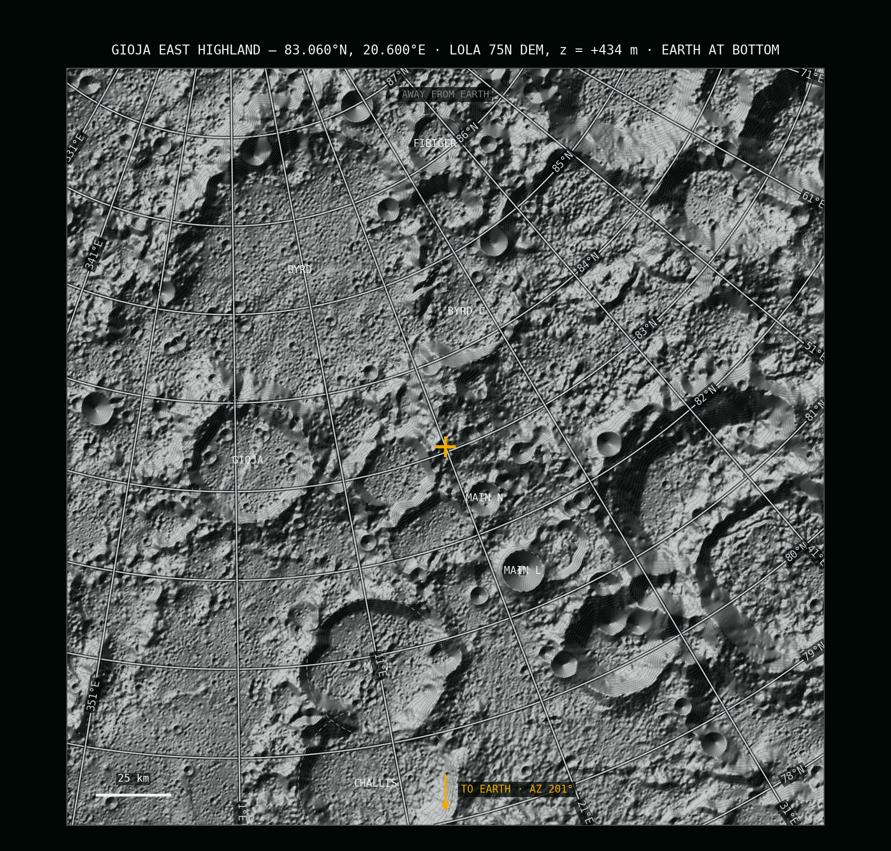
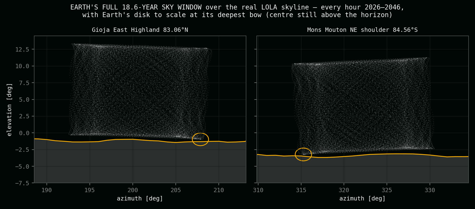
Gioja East Highland — 83.06°N, the northern site
A broad highland rise 68 km east of Gioja crater, 434 m up, with the country falling away to the south — the skyline under Earth's track sits a full degree below level. The full disk stands clear 93.3% of the time, the horizon crosses it 6.7% of all hours, and in two hundred years of tested sky Earth is never fully hidden. Closest approach of the centre to the skyline: +0.34°.
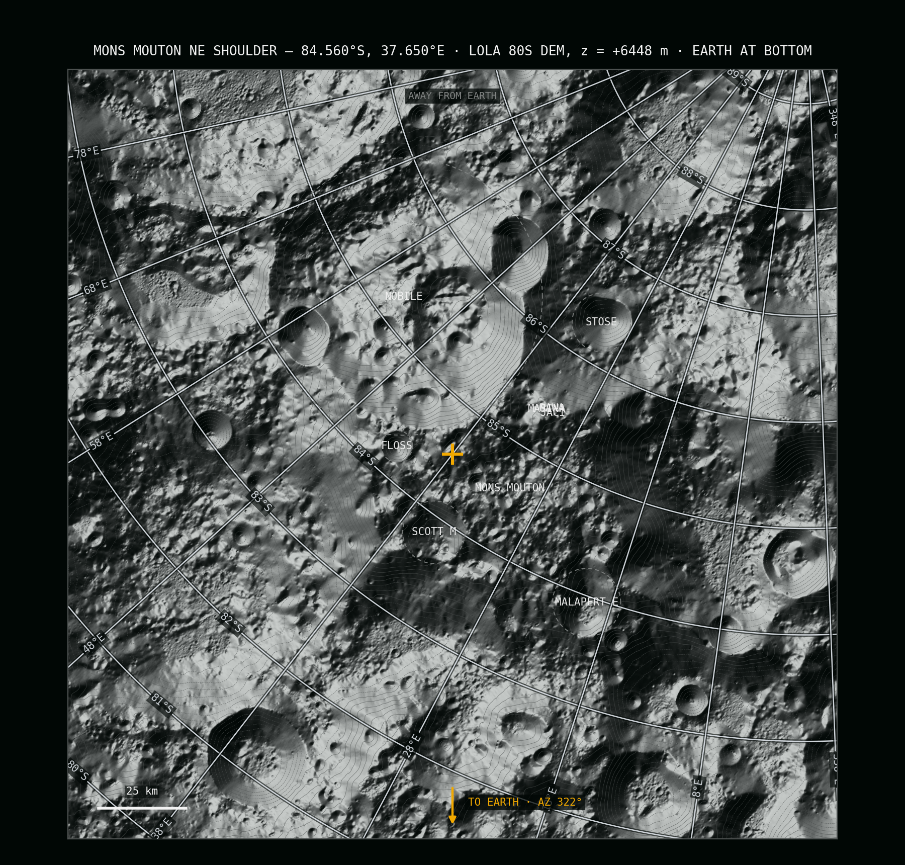
Mons Mouton NE shoulder — 84.56°S, the southern site
The northeastern shoulder of the lunar south's highest mountain, 6,448 m up beside Floss crater, looking 3.3° down at the skyline over the plateau rim. The full disk stands clear 92.5% of the time, the horizon crosses it 7.5% of all hours — thirteen bows a year — and Earth is never fully hidden. Closest approach of the centre: +0.24°. Two Artemis III candidate regions share the massif.
Side by side
The two sites, measure for measure
All values from this project's 2026 audit: JPL DE440 sky geometry tested hourly 2026–2046 against laser-measured skylines, with the worst case re-verified for every 18.6-year window between 1900 and 2100. The per-hemisphere comparison tables — every candidate that was tested and why it fell — are on the northern and southern site pages. The full method and source record — ephemeris basis, horizon ray-marching, the landing-pad test — are on the validation page.
| Measure | Gioja East Highland (N) | Mons Mouton NE shoulder (S) |
|---|---|---|
| Coordinates | 83°03′36″ N, 20°36′00″ E | 84°33′36″ S, 37°39′00″ E |
| Height (LOLA laser datum) | +434 m | +6,448 m |
| Distance from the pole | ≈ 210 km | ≈ 165 km |
| Full Earth disk visible | 93.3% of the time | 92.5% of the time |
| Both worlds in frame | 6.7% — one hour in fifteen | 7.5% — one hour in thirteen |
| Earth fully hidden | never | never |
| Bows per year | ≈ 10 | ≈ 13 |
| Deepest bow (share of disk below) | 32% of diameter | 35% of diameter |
| A bow lasts | ~56 hours, up to 87 | ~51 hours, up to 87 |
| Centre-to-skyline margin, 1900–2100 | +0.34° | +0.24° |
| Margin across the 640 m landing pad | ≥ +0.21° | ≥ +0.17° |
| Earth stands | low in the SSW (az 192°–209°) | low in the NW (az 314°–331°) |
| Earth's elevation range | −1.0° … +13.4° | −3.2° … +11.3° |
| Skyline under Earth's track | −1.0° (sunken horizon) | −3.3° (high vantage) |
| Nearest named ground | Gioja 68 km W · Main N 22 km S | Floss 16 km NE · Artemis III regions on the massif |
Two hemispheres, one behaviour: Earth rides low over a horizon that sits below the camera, bows into it on the Moon's 27.21-day nod, and always keeps more than half of itself in the sky. The south bows more often and deeper; the north stands on quieter ground with the larger margin.
The hunt
How the two spots were found
"Never more than half" is a guarantee, and guarantees are engineering. The search ran in four layers, each one eliminating most of what the previous layer let through.
1 · Exact sky
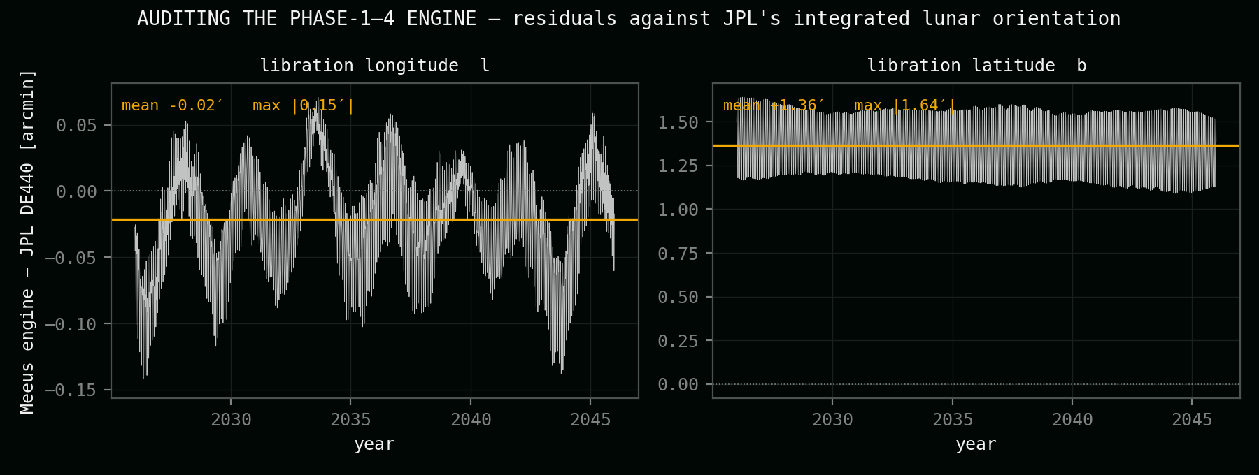
Earth's position from every candidate point, computed from JPL's DE440 ephemeris — the planetary data NASA navigates by — and cross-checked against JPL's Horizons service to within an arcsecond. 69,000 grid points scanned per hemisphere.
2 · Real horizon
No flat-Moon assumptions: for every finalist, the visible skyline was ray-marched out of NASA's LOLA laser elevation maps, azimuth by azimuth, out to 240 km — because the criterion lives or dies on where the ground actually stands against the sky.
3 · The pad test
A lander never touches down exactly on its marker. Every candidate was re-tested at sixteen offset positions across a 640-metre pad — and most "perfect" spots died right here, their guarantee hiding behind a knoll one step away.
4 · Two hundred years
The survivors' worst hour was hunted through the full 1900–2100 record — every 18.6-year wobble cycle, every depth season. The margins barely move between cycles: +0.34° north, +0.24° south, in the worst window as in the best.
The figures behind the sites
The search in six pictures — the wobble itself, what it does at each latitude, the bows against real skylines, twenty years of guarantee, and the audit that anchors it all. The full journey is on the validation page.
Questions about the sites
What the half-set rule means, why it leads to these two places, and what is — and is not yet — proven.
What exactly is the half-set rule?
Earth may bow behind the lunar horizon — that contact is the picture this project exists for — but its centre must never drop below the visible skyline. At the deepest legal bow, half the disk stands behind the Moon's ground and half in the sky. Both chosen sites keep a measured safety margin above that line, in every tested year from 1900 to 2100.
Does Earth ever disappear at these sites?
No. Not for an hour, in two hundred years of tested sky. That is the point of the rule: the horizon takes a bite — up to a third of the disk on the deepest bows — but the majority of the planet, including its centre, always stays up.
Why these latitudes and not the famous pole sites?
The famous near-pole rims — Shackleton, the Connecting Ridge, Peary — lose Earth completely for up to two weeks every month: wrong regime. The best published Earth-view sites fail more subtly — either Earth never touches the horizon at all, or it sinks past the middle on deep bows. The half-set rule picks its own ground: high enough for drama, robust enough for a promise.
What is the pad test?
Landers miss their markers — by metres on a good day, hundreds on a bad one. So every candidate's guarantee was re-verified at sixteen positions across a 640-metre pad. It is brutal: spots with beautiful numbers at the marker lost Earth entirely one knoll-shadow away. Both chosen sites hold their full guarantee everywhere on the pad.
How solid are the numbers?
The sky side is exact: DE440 ephemeris geometry, validated against JPL Horizons to about an arcsecond, stable to a fiftieth of a degree across every 18.6-year window in two centuries. The ground side is as good as current lunar mapping: laser-altimetry skylines at 80–240-metre grid resolution, with the margins sized so the guarantee survives that uncertainty. Published full-cycle JPL studies anchor the comparison sites.
What still needs proving?
The last metres. Each bow's exact depth moves by real fractions of a degree with every metre of local ridge, and the audit's horizon is built from 80–240-metre laser grids. The next phase extracts metre-class horizon profiles for both pads from orbital stereo imagery. Site-grade truth on the Moon is earned in metres, not degrees.
Read the sites in detail
Each site has its own page with the full per-hemisphere candidate table — and the validation journey, with the audit, the horizon method and the complete source record, has its own.
See where the camera would stand
Explore each site in full, read how every number was rebuilt and audited, or step back to the wider project to see how the vantage point fits the rest of the concept.