
Northern site · the half-set guarantee
83°03′36″ N · 20°36′00″ E
A quiet highland east of Gioja crater, 210 kilometres from the north pole. Earth hangs low in the south and bows into the skyline ten times a year — and however deep the bow, more than half of the planet always stays in view. Guaranteed, for any year, anywhere on the landing pad.
The site
The highland east of Gioja
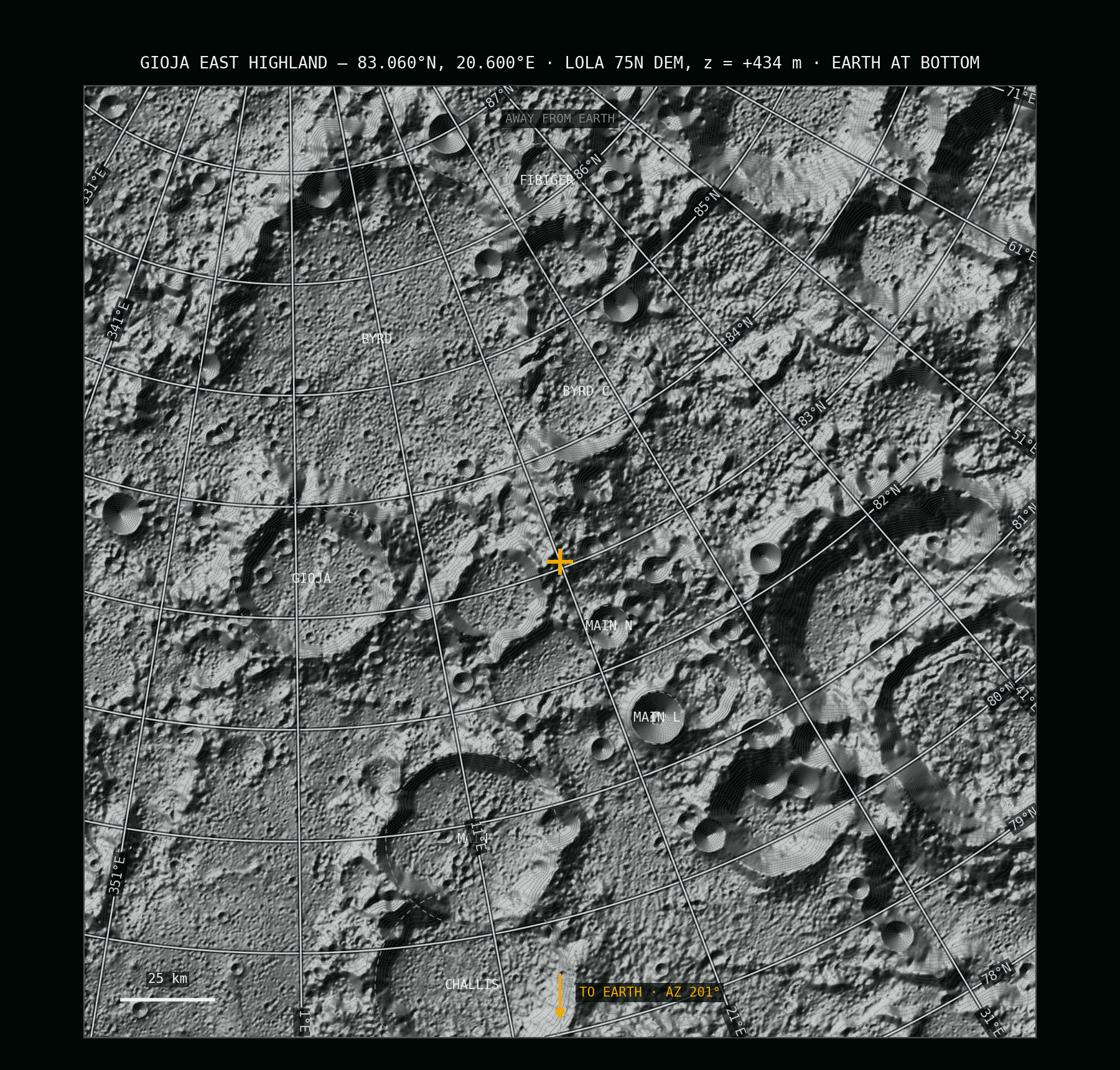
The site is a broad rise of old highland ground 68 kilometres east of Gioja crater and 22 kilometres north of the small crater Main N — 434 metres above the lunar datum, with open lowland falling away to the south. That falling foreground is the trick: the visible skyline toward Earth sits a full degree below level, so the planet bows into a sunken horizon and its centre never goes under. Gioja, the nearest named landmark, honours Flavio Gioja — the mariner credited with perfecting the compass. Fitting neighbours for an instrument built to hold one bearing forever.
| Property | Value |
|---|---|
| Latitude | 83.060° N (83° 03′ 36″ N) |
| Longitude | 20.600° E (20° 36′ 00″ E) |
| Height | +434 m (LOLA laser altimetry) |
| Distance from the north pole | ≈ 210 km |
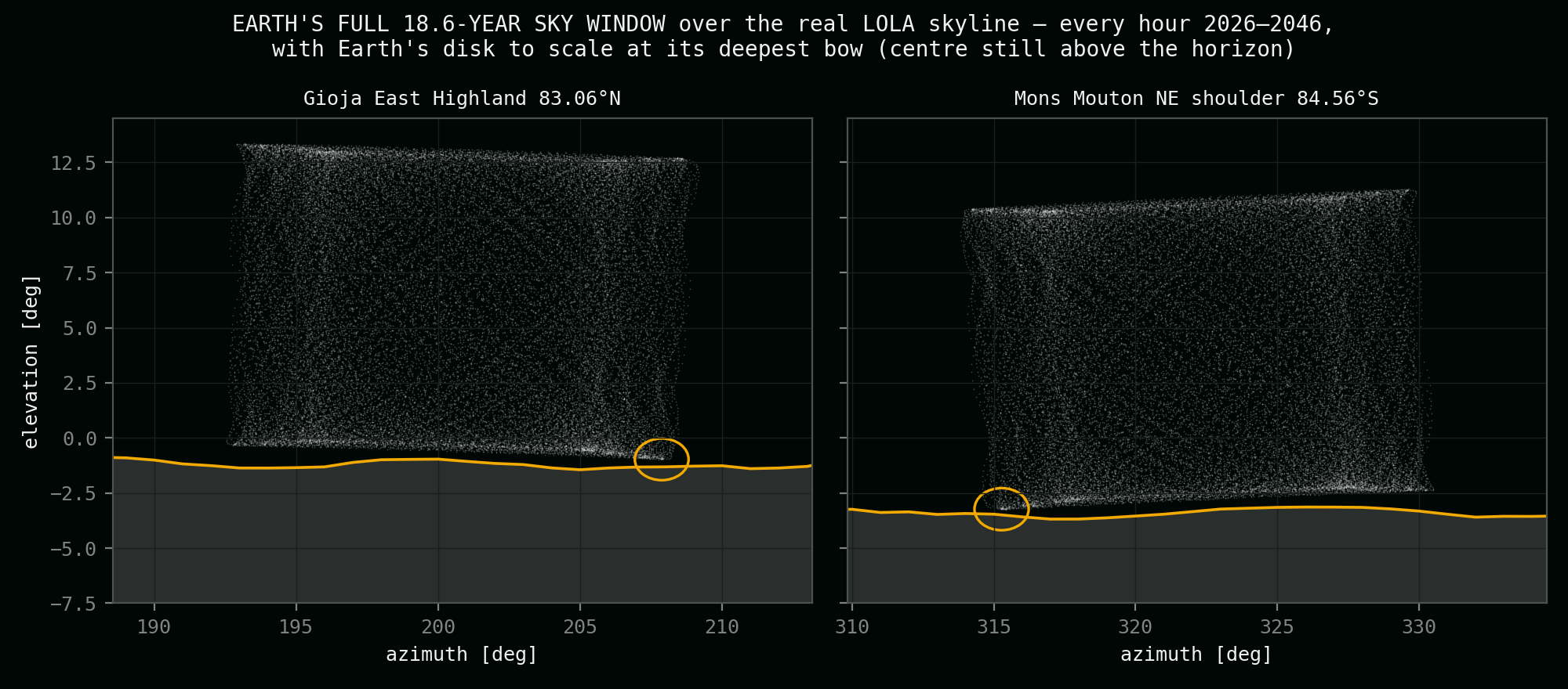
| Earth's place in the sky | low in the south-southwest, between −1.0° and +13.4° |
| Skyline under Earth's track | −1.0° — a sunken horizon |
The record
Two centuries, hour by hour
These values come from this project's audit: exact JPL DE440 sky geometry, tested every hour for twenty years against a skyline ray-marched out of NASA's laser elevation maps — and the worst case re-checked across every 18.6-year cycle from 1900 to 2100. Earth is never fully hidden here. Not for an hour. Every number traces to that audit — method, cross-checks and sources on the validation page.
Of the time the full disk stands clear of the horizon
Of the time the horizon crosses Earth's disk — both worlds in frame
With Earth fully hidden — in two hundred years of tested sky
Closest the centre ever comes to the skyline — the half-set guarantee
The bow
Earth bows — and never goes under
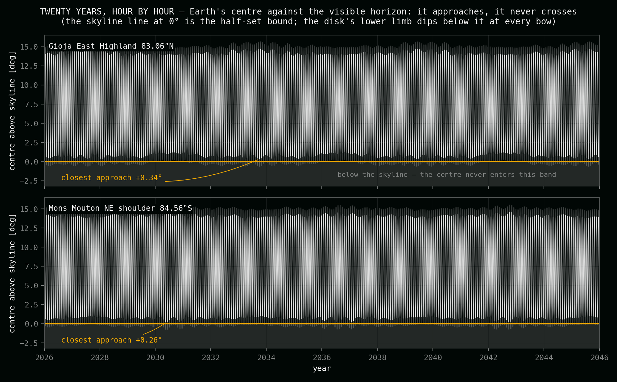
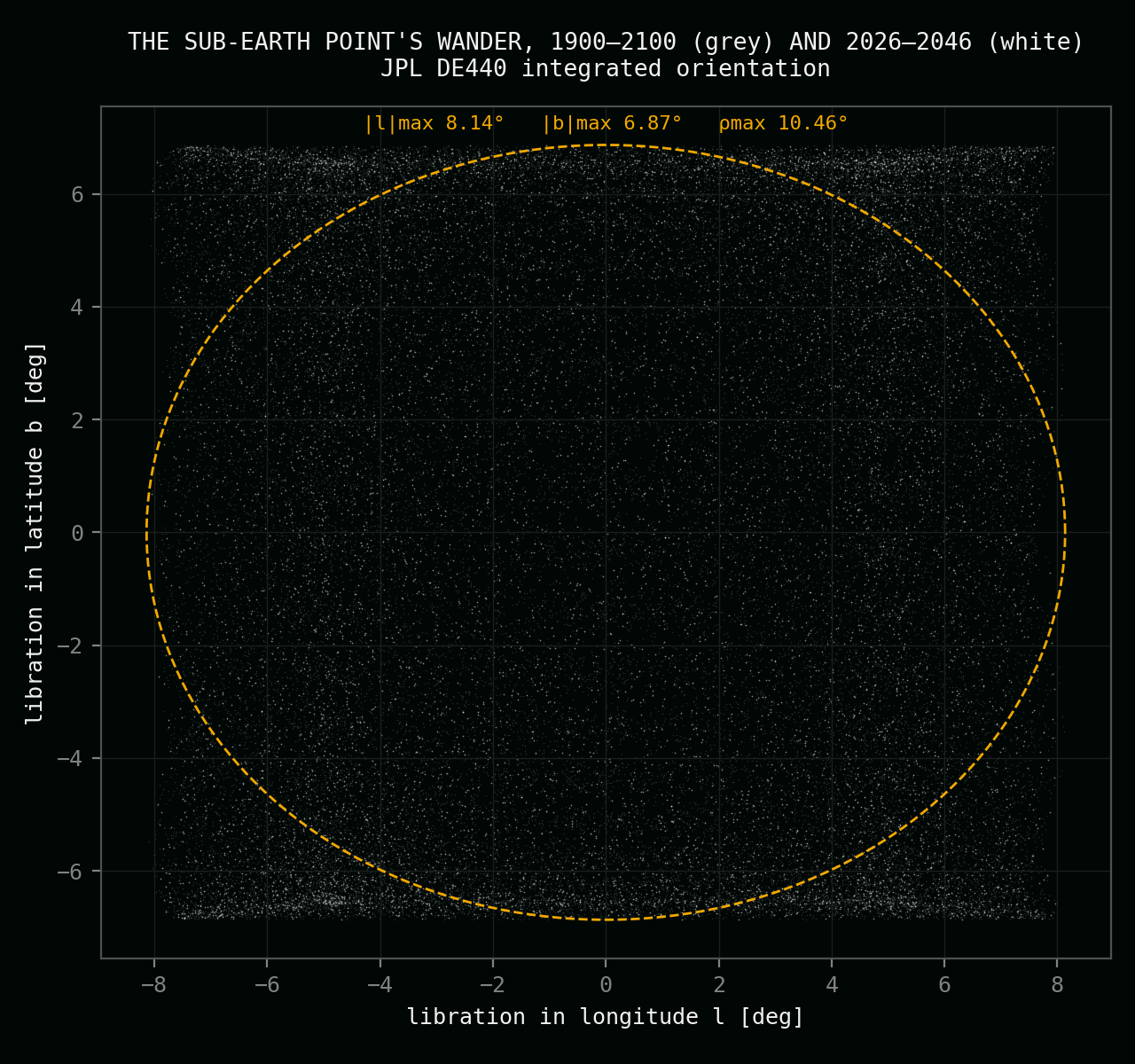
From this highland Earth circles a small patch of southern sky. On the Moon's 27.21-day nod the planet sinks toward the horizon; in the deep seasons of the cycle the dark lunar ground bites into the bright disk for two or three days at a time. At the very deepest bow on record — checked against every year from 1900 to 2100 — about a third of the disk stands below the skyline. Never half. The depth of the bows breathes with a 173-day rhythm, the pattern turns over six years, and after 18.6 years every variation has played out once.
- About 10 bows a year; each "both worlds" episode lasts ~56 hours, the longest 87
- Deepest bow: 32% of Earth's diameter below the skyline — the centre always stays up
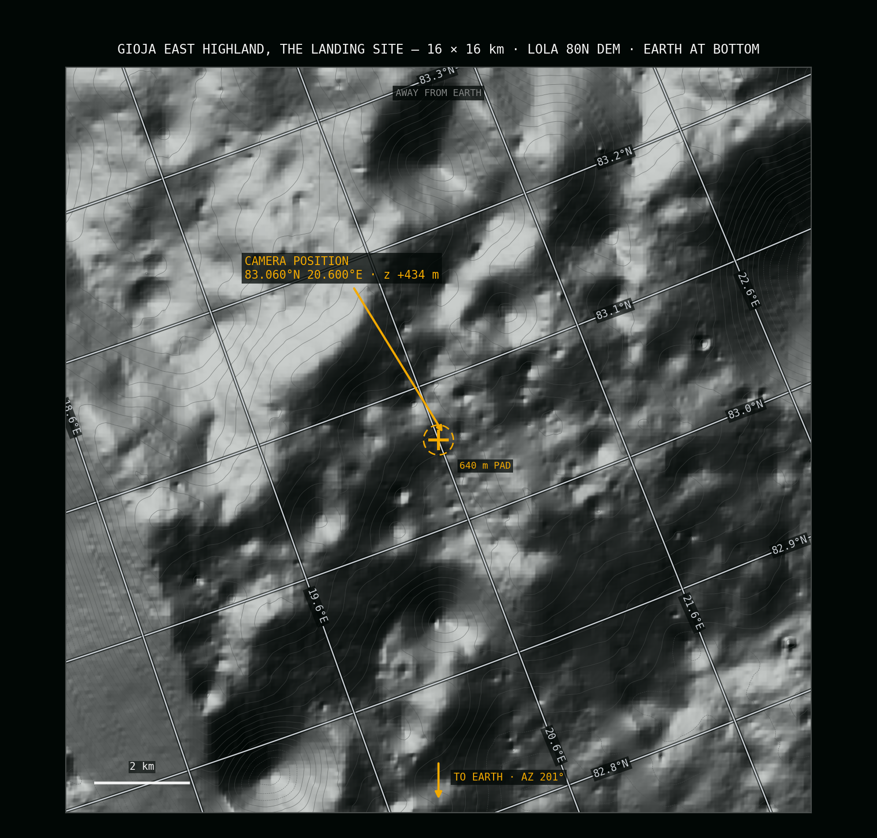
- The guarantee survives landing scatter: it holds everywhere within a 640-metre pad
The northern field
How the north's candidates compare
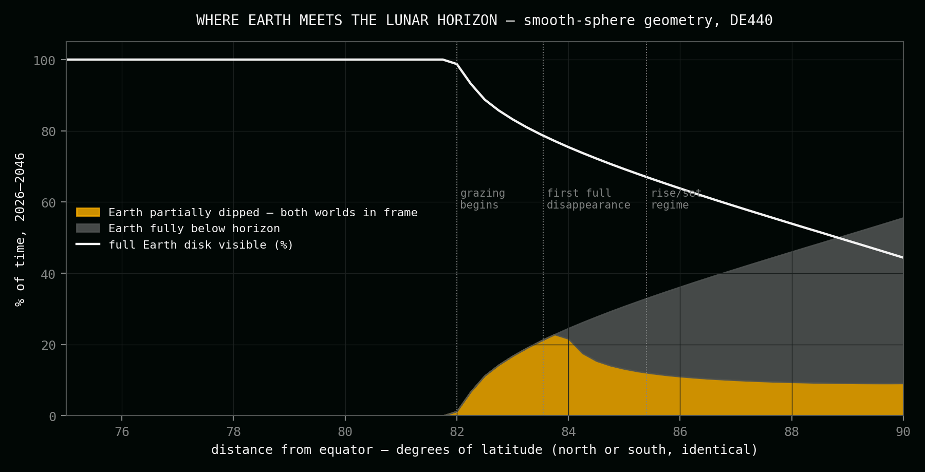
Every serious northern candidate, tested against one rule: Earth must never sink more than half below the visible horizon — for any epoch, with landing tolerance. Published full-cycle values (JPL, measured terrain) for the classic sites; this project's laser-altimetry audit for the rest. Closer to the pole the view of Earth collapses; lower and flatter, the bows die out or the ground fails the pad test. One site holds the line.
| Site | Coordinates | Height | Full disk | Both worlds | Hidden | Verdict under the half-set rule |
|---|---|---|---|---|---|---|
| Gioja East Highland — this site | 83.06°N, 20.60°E | +434 m | 93.3% | 6.7% | 0% | Selected — margin +0.34°, robust across the pad |
| Highland ridge crest, 9 km NE | 83.15°N, 21.48°E | +649 m | 89.5% | 10.5% | 0% | Rejected — one 320 m step hides Earth behind a knoll |
| Graze plain near the prime meridian | 82.00°N, 1.50°E | −730 m | 89.2% | 10.8% | 0% | Rejected — the margin collapses within the landing pad |
| Peary south flank / Byrd north rim | 87.02°N, 8.02°E | 1,540 m* | 85.4% | 10.8% | 3.9% | Rejected — Earth disappears completely, gaps of ~3 days |
| Hinshelwood rim | 89.66°N, ~47°W | 360 m* | 57.0% | 13.8% | 29.2% | Rejected — Earth gone ~29% of the time |
| Peary near-pole rim | 89.84°N, ~120°E | 280 m* | 53.1% | 13.8% | 33.1% | Rejected — 4.5 km from the pole, Earth gone a third of the time |
| Whipple rim | 89.38°N, 126.48°E | 444 m* | 52.4% | 13.8% | 33.8% | Rejected — monthly rise and set |
* Published radar-era heights and full-cycle percentages (Bryant 2009, JPL IPN Progress Report 42-176, Table 4); the other rows are this project's DE440 + laser-altimetry audit, 2026. The near-pole rims trade Earth away for sunlight and ice — they are future-base ground, not portrait ground. The southern half of the field is on the locations page.
Site views
The geometry of the northern site — its sky window over the real skyline, the wobble that drives the bows, and where this latitude sits on the regime map.
In plain language
What this site actually is
The EXAX project aims to place a single camera on the surface of the Moon and point it at Earth — a fixed eye on solid ground that keeps the planet in frame for years on end. The brief behind this page is exact: find a place where the lunar horizon regularly cuts across the bright disk — two worlds in one photograph — but where Earth never sinks more than half below that horizon. Not in the deepest bow of the deepest year. Not ever.
That single sentence is a hard engineering constraint, and it eliminates almost everything. Too far from the pole and Earth never touches the horizon at all; too close and it vanishes for days or weeks. Even inside the right band, most ground fails quietly: a candidate that looks perfect on the map can lose the guarantee one rock-throw away, where a local knoll blocks the sightline. This project tested for exactly that — every finalist was re-checked at sixteen surrounding positions, because a camera that lands 300 metres off the marker must inherit the same sky.
This highland east of Gioja is the north's answer. It stands 434 metres above the datum with open country falling away to the south, which drops the visible horizon a full degree below level — Earth bows into a hollow. Ten times a year the planet's lower edge slips behind the skyline; the picture for those days is the one this project exists for, the home planet half-risen behind Moon rock. At the deepest bow in two hundred years of tested sky, about a third of the disk is hidden. The centre — and with it, the majority of Earth — never goes under.
The numbers come from JPL's DE440 planetary ephemeris — the one NASA missions navigate by — turned into local sky tracks for this exact spot, then tested hour by hour against a horizon ray-marched out of NASA's LOLA laser elevation maps. The guarantee figure, +0.34°, held in every 18.6-year window between 1900 and 2100 with almost no variation. The remaining step before a camera stands here is a metre-class survey of the southern skyline, to fix each bow's depth to the last fraction of a degree.
Questions
What you need to know about this northern location.
Why this exact position?
It is the only northern point found that delivers monthly horizon-crossings while keeping the half-set guarantee robustly — Earth's centre stays at least 0.34° above the skyline in every tested year from 1900 to 2100, and that margin survives at every position within a 640-metre landing pad. Sweeter-looking spots exist nearby; none survive the pad test.
What does "Gioja East Highland" mean?
The rise itself has no official name, so the project anchors it to its nearest named landmark: Gioja crater, 68 km west, named for Flavio Gioja, the medieval mariner credited with perfecting the ship's compass. The small craters Main N and Main L sit just to the south; Byrd C to the northeast. The coordinates, not the name, are the site.
How often are both worlds in one frame?
For 6.7% of all hours — about one hour in fifteen — the horizon line crosses Earth's disk. The rhythm is the Moon's 27.21-day nod: about ten bows a year, each lasting around 56 hours, their depth breathing over 173 days, the full pattern repeating every 18.6 years.
Where does Earth stand in the sky here?
Low in the south-southwest, drifting through a 17°-wide window between azimuths 192° and 209°, never higher than 13.4° and never lower than −1.0° — against a skyline that itself sits a degree below level. The disk is 1.8–2.0° wide. The whole 18.6-year wander fits a fixed lens; nothing ever needs to track.
How was the location confirmed?
Three layers: exact sky geometry from JPL's DE440 ephemeris (cross-checked against NASA's Horizons service to within an arcsecond); a real horizon ray-marched from NASA's LOLA laser elevation maps in every direction Earth visits; and a robustness sweep at sixteen offset positions around the marker. The worst case was then re-tested in every 18.6-year window from 1900 to 2100.
What is the remaining step before installation?
A metre-class survey of the southern skyline. The audit's horizon comes from laser maps at 80–240-metre resolution — good enough to certify the guarantee with margin, but each bow's exact depth still moves by real fractions of a degree with every metre of local ridge. Extracting a centimetre-grade horizon from orbital stereo imagery is the next phase.
Sources and related pages
The full validation — ephemeris basis, the laser-altimetry horizon method, the pad-robustness test, published-study cross-checks, and the complete source record — is on the validation page and in the downloadable science dossier.