The validation journey
We didn't trust our own numbers — so we rebuilt them
Before recommending a camera site on another world, this project re-derived every number behind its site map from scratch: different software, a stronger reference, and an audit that went looking for its own mistakes. It found one — and a better map.
The outcome
What the audit established
The first study's geometry survived almost untouched; one constant flaw in its sky engine was found and corrected; and scoring the Moon against the project's true rule — the horizon may cut into Earth's disk, but never past half — selected two sites no one had named before, each certified against real laser-measured terrain, landing scatter, and two hundred years of sky.
Candidate-site rows reproduced independently, to better than 0.03°
The one real flaw: a constant latitude offset in the original sky engine, now corrected everywhere
Worst-case difference between any two 18.6-year windows, 1900–2100 — the view is the view forever
Agreement with NASA's public Horizons service at spot-checked epochs
Step one of six
A stricter engine
The first study (four phases, spring 2026) answered a strict question: where on the Moon does Earth never set? It computed the Moon's slow wobble — libration — from a classic textbook series (Meeus, Astronomical Algorithms, chapter 53), traced Earth's position in the sky of every candidate site, and tested those sightlines against laser-altimeter terrain. It found the edge of the never-sets zone at about 83° latitude and selected two sites just inside it.
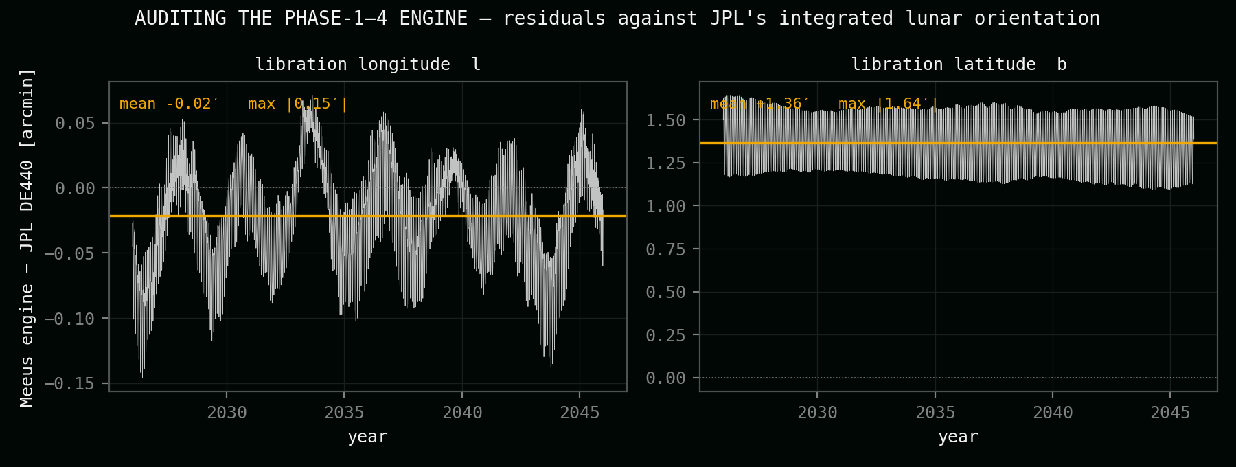
The re-validation rebuilt that pipeline on different foundations. Instead of the textbook series, it used JPL's numerically integrated lunar orientation itself — the DE440 ephemeris that NASA missions navigate by — evaluated hour by hour from 2026 to 2046 and at six-hour steps across two full centuries, 1900 to 2100. Single epochs were cross-checked against JPL's public Horizons service and agreed to about an arcsecond. Where the first study and the rebuild disagreed, the rebuild wins by construction: it is the reference.
Step two of six
The audit found a real flaw
The textbook engine carries a constant offset of 1.4 arc-minutes (0.023°) in libration latitude against the integrated truth. It was invisible to the original validation, which only tested the time-varying part of the signal — a constant slips through every variability check. Propagated through all 52 candidate sites, every northern clearance margin had been about 0.02° too optimistic, and every southern one about 0.02° too safe.
Small — but the first study's flagship northern site carried a safety margin of only a quarter of a degree, so the correction matters exactly where the decisions were tightest. Every number on this website now includes the correction; the corrected engine agrees with the reference to ±0.003°.
Step three of six
The geometry survived
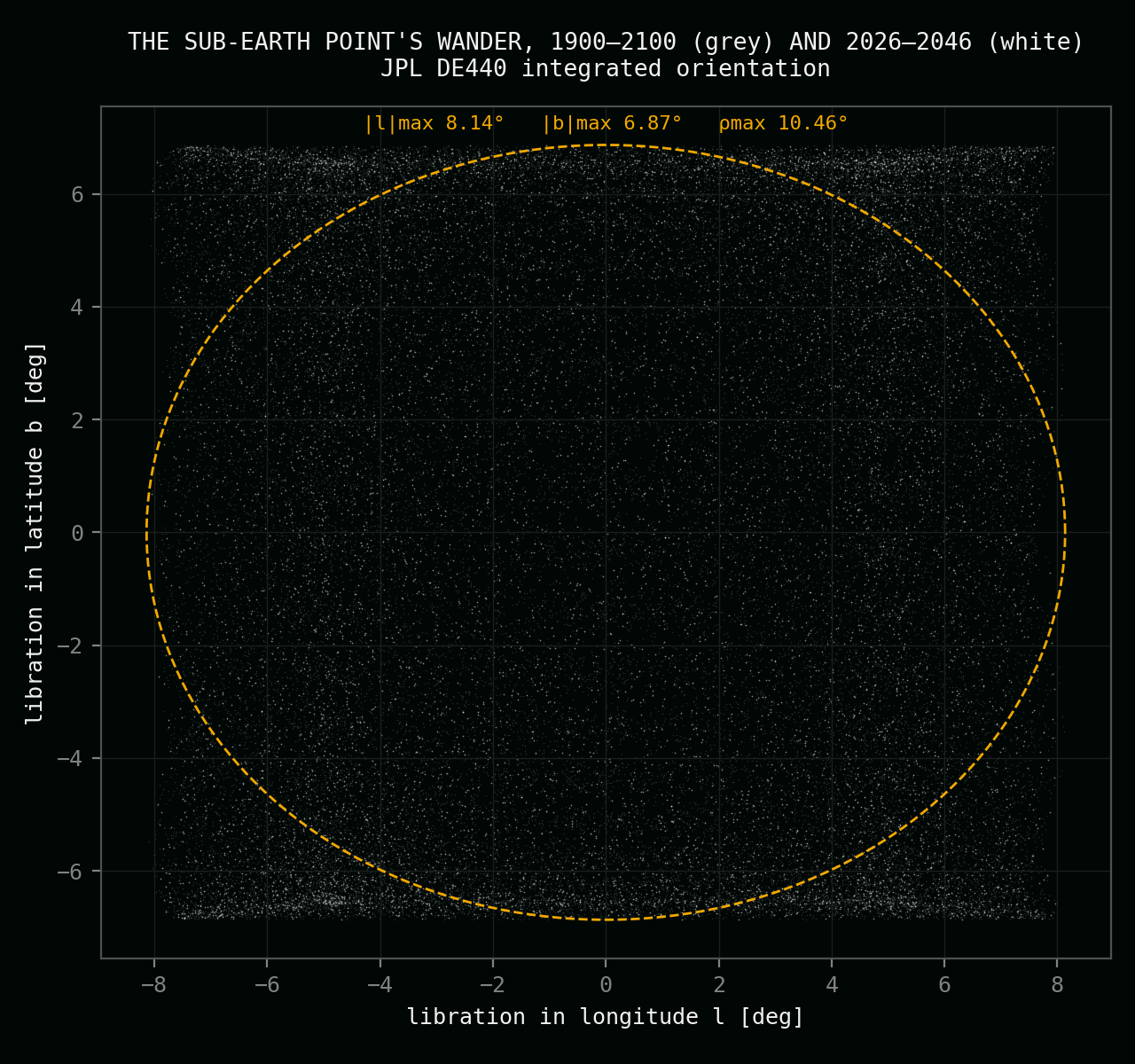
With the bias corrected, the first study's core results reproduced almost exactly. The full libration envelope — how far the sub-Earth point ever wanders — came out at ±8.14° east–west and ±6.87° up–down, never more than 10.46° from centre. All 52 candidate-site elevation ranges matched to better than 0.03°. The terrain data behind the final phase checked out too: the laser-altimeter map files, their stated parameters, even their byte counts match the published NASA archive.
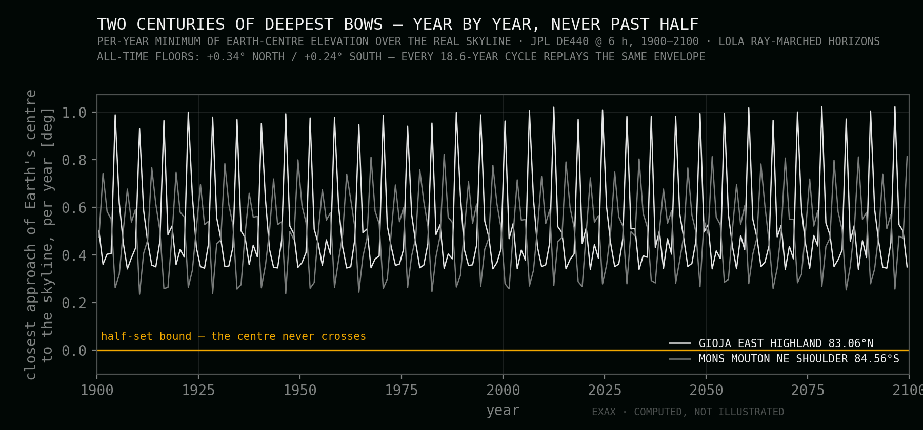
A new stability test added something the first study never claimed: any 18.6-year window between 1900 and 2100 produces the same worst-case Earth positions to within 0.02°. A guarantee written for one cycle holds for every cycle — for a camera meant to stand for decades, that is the licence to promise.
Step four of six
The rule that picks the ground: never more than half
The project's brief is a single sentence with teeth: the lunar horizon may cut into Earth's disk — that contact is the photograph — but Earth must never sink more than half below it. Formally: the planet's centre must never drop below the visible skyline. Not in the deepest bow of the deepest year, not anywhere a lander might actually set the camera down.
That sentence redraws the map. Sites where Earth never touches the horizon are out — majestic, but motionless. Sites where Earth fully sets are out, however famous their statistics. What remains is a knife's edge: ground where the bow is deep enough to matter and bounded enough to promise. On level terrain that edge is a band barely one and a half degrees of latitude wide; real terrain bends it — height drops the local skyline by about two degrees per kilometre of summit, and a sunken foreground drops it further. The search therefore had to treat the ground as seriously as the sky.
Step five of six
The ground entered the equation
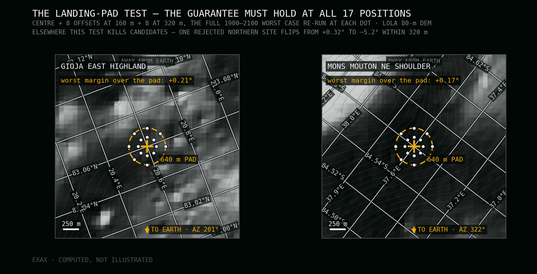
A guarantee against the horizon needs the real horizon. For every finalist the audit ray-marched NASA's LOLA laser elevation grids — 240-metre resolution out to 240 kilometres, 80-metre close in — into a skyline profile, azimuth by azimuth, and tested Earth's centre against it hour by hour. Then came the harshest filter: because landers miss their markers, every candidate was re-verified at sixteen offset positions across a 640-metre pad.
The pad test rewrote the shortlist. Points with beautiful numbers at the marker lost Earth entirely one knoll-shadow away — one candidate's margin collapsed from a healthy +0.32° to −5.2° within 320 metres. Famous ground fell too: on the best-known southern summit, the deepest bows push Earth's centre below the visible skyline — more than half the planet gone, a quiet violation no any-part statistic reveals; and the north's best published viewpoint loses Earth completely for days at a time. What survived, in each hemisphere, was exactly one robust site: a highland east of Gioja at 83.06°N and the northeast shoulder of Mons Mouton at 84.56°S.
Step six of six
What the literature already knew — and didn't
The polar mountains were not unmeasured. A 2009 JPL communications study (Bryant) had walked Earth across radar-measured polar terrain hour by hour through a full 18.6-year cycle and published per-site visibility percentages; NASA's 2011 laser-altimeter maps (Mazarico et al.) and the Artemis III site assessments corroborate it. This project's exact geometry agrees with every published value once each site's measured skyline is taken into account — those studies anchor the comparison tables on both site pages, and where published and audited values describe the same ground, they meet.
But the published record answers a different question — how much Earth, how much Sun — and no study had ever scored the Moon against the half-set bound, let alone with landing tolerance. The two selected sites are new ground in the literal sense: found by this audit, on terrain the classic surveys measured for other purposes, and checkable by anyone with the same public data. No single number carries the claim; the agreement of methods does.
Honestly
What remains open
The skylines that certify the guarantee come from laser grids at 80-to-240-metre resolution — good enough to hold the margins with room to spare, and the audit sized those margins accordingly. But each bow's exact depth still moves by real fractions of a degree with every metre of local ridge. The next phase extracts metre-class horizon profiles for both landing pads from orbital stereo imagery, in the small azimuth sectors where Earth bows — turning a certified guarantee into a surveyed one. A modern-data recomputation of the classic published comparison percentages is equally bounded, known work.
Site-grade truth on the Moon is earned in metres, not degrees — and that is exactly the next phase of this project.
Provenance
The source record
Everything above traces to public, checkable sources. The same record is bundled in the downloadable science dossier.
Ephemeris & orientation
- Park, Folkner, Williams & Boggs (2021), The JPL Planetary and Lunar Ephemerides DE440 and DE441, Astronomical Journal 161:105 — the ephemeris and integrated lunar orientation this rebuild stands on.
- Meeus (1998), Astronomical Algorithms, 2nd ed., chapter 53 — the first study's analytic engine, audited here: a constant +1.4′ latitude bias against DE440, corrected in every number on this site.
Terrain & maps
- NASA LRO LOLA gridded polar elevation models (LDEM 75°N/S at 240 m, 80°N/S at 80 m, PDS Geosciences Node) — the terrain behind this audit's ray-marched skylines, site maps and pad-robustness tests; projection verified against published spot heights.
- NASA LRO LOLA polar elevation models (LDEM 75°N/75°S, 60 m) — the terrain behind the first study's final phase; file parameters and integrity independently re-verified in this audit.
- IAU Gazetteer of Planetary Nomenclature (USGS, LOLA reference frame) — official names and positions of every crater and mountain on the site maps: Gioja, Main N, Byrd, Mons Mouton, Floss and neighbours.
Published visibility & illumination studies
- Bryant, S. (2009), Lunar Pole Illumination and Communications Maps Computed from GSSR Elevation Data, JPL IPN Progress Report 42-176 — per-site Earth-visibility percentages across a full 18.6-year cycle; anchors the comparison tables on both site pages.
- Mazarico, Neumann, Smith, Zuber & Torrence (2011), Icarus 211:1066 — LOLA-based illumination and Earth-visibility maps of both poles, hourly, full cycle.
- Gorkavyi, Krotkov & Marshak (2023), Atmospheric Measurement Techniques 16:1527 — Earth observation from the lunar surface: libration periods and Earth's 1.8–2.0° angular diameter.
- Gorkavyi et al. (2021), Frontiers in Remote Sensing 2:724074 — an EPIC-type Earth camera at the lunar south pole, composed low over the horizon.
- De Rosa et al. (2012), ESA lunar lander site studies — Mons Mouton plateau Earth-contact windows.
- Basilevsky et al. (2019), Solar System Research 53:383 — Malapert summit visibility and illumination.
Mission context
- NASA Artemis III candidate landing regions (2022/2024) — Malapert Massif, Mons Mouton, Mons Mouton Plateau, Connecting Ridge, de Gerlache Rim, Peak Near Shackleton.
Stand on the verified ground
Read the two featured sites the validation produced, or watch the verified geometry move the Earth in the lunar sky.