
Southern site · the half-set guarantee
84°33′36″ S · 37°39′00″ E
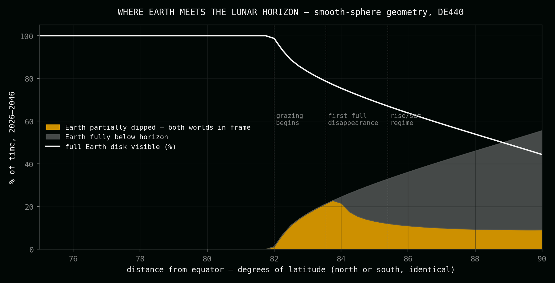
On the northeast shoulder of Mons Mouton's summit plateau, 6,448 metres up — the highest ground of the lunar south. Earth hangs low in the northwest and bows into a skyline three degrees below level, thirteen times a year. However deep the bow, more than half of the planet always stays in view.
The site
The shoulder of the great mountain
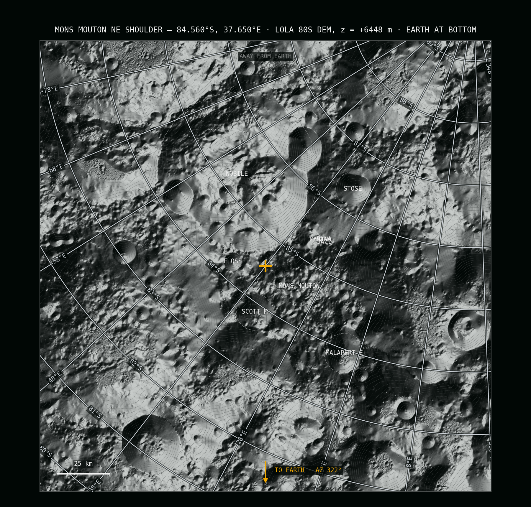
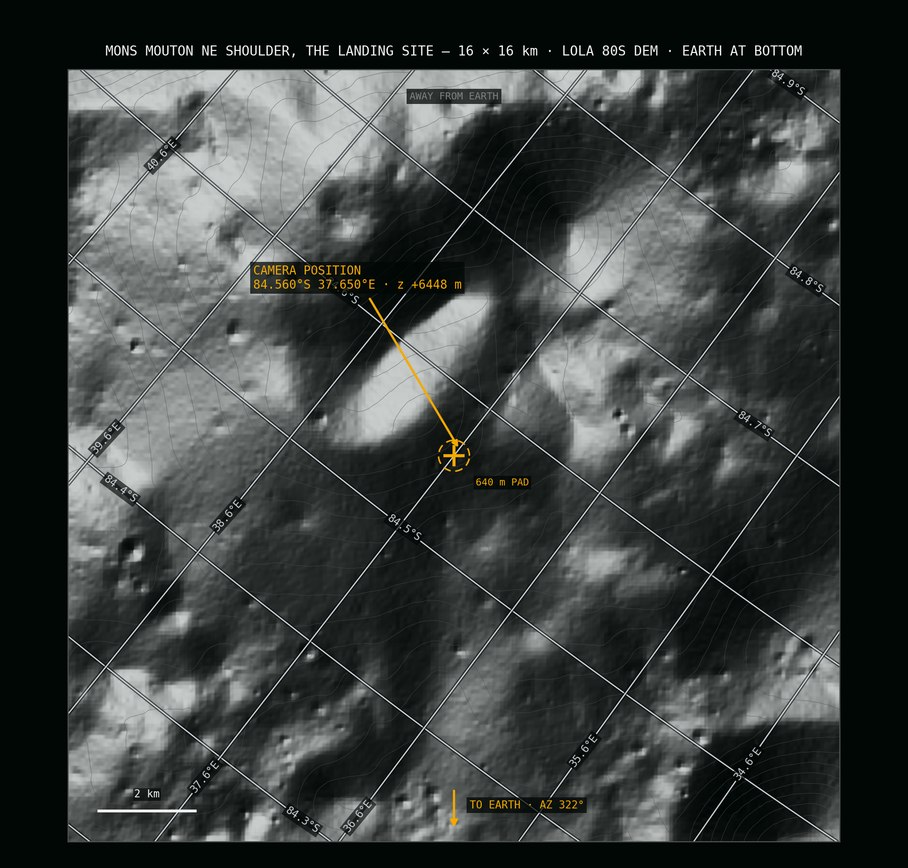
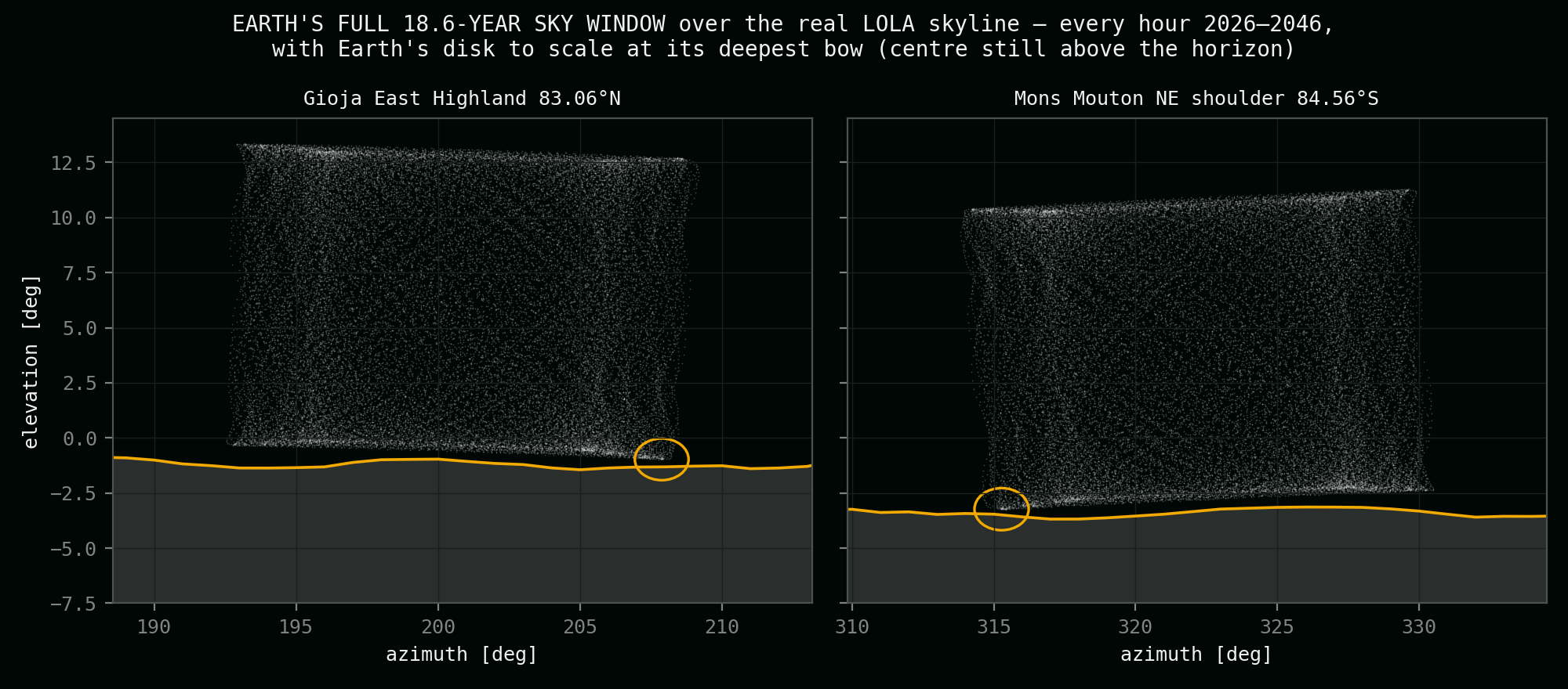
Mons Mouton is a 130-kilometre massif, the highest mountain of the Moon's south. NASA has listed two Artemis III candidate landing regions on it, targeted its plateau for the VIPER ice rover, and in March 2025 the IM-2 Athena lander touched down on its flank. This site is the plateau's northeastern shoulder: 6,448 metres above the datum, beside the small crater Floss, where the high ground falls away toward the lowlands of Scott. From here the camera looks northwest, far down over the plateau's rim — the visible skyline sits 3.3° below level, and Earth bows into that hollow without ever sinking past its middle.
| Property | Value |
|---|---|
| Latitude | 84.560° S (84° 33′ 36″ S) |
| Longitude | 37.650° E (37° 39′ 00″ E) |
| Height | +6,448 m (LOLA laser altimetry) |
| Distance from the south pole | ≈ 165 km |
| Earth's place in the sky | low in the northwest, between −3.2° and +11.3° |
| Skyline under Earth's track | −3.3° — looking far down from the heights |
The record
Two centuries, hour by hour
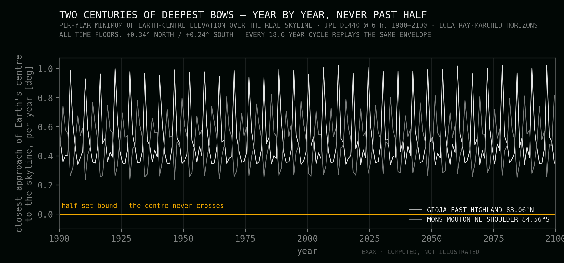
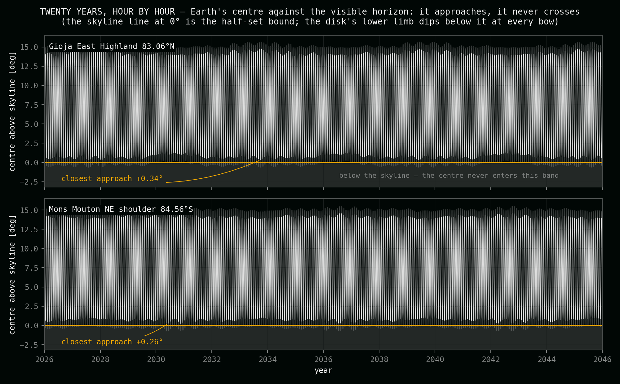
These values come from this project's audit: exact JPL DE440 sky geometry, tested every hour for twenty years against a skyline ray-marched out of NASA's laser elevation maps — and the worst case re-checked across every 18.6-year cycle from 1900 to 2100. Earth is never fully hidden here. Not for an hour. Every number traces to that audit — method, cross-checks and sources on the validation page.
Of the time the full disk stands clear of the horizon
Of the time the horizon crosses Earth's disk — both worlds in frame
With Earth fully hidden — in two hundred years of tested sky
Closest the centre ever comes to the skyline — the half-set guarantee
The bow
Thirteen bows a year, never past half
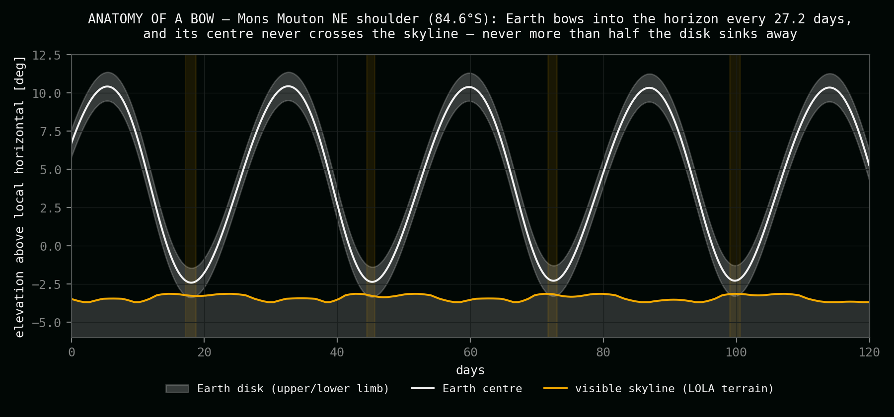
From the shoulder Earth circles a small patch of northwestern sky. On nearly every 27.21-day cycle the Moon's nod carries the planet down into the sunken skyline: for about two days the dark plateau rim cuts across the bright disk — ocean, cloud and Moon rock sharing one picture — and then Earth climbs back. At the very deepest bow on record, checked against every year from 1900 to 2100, just over a third of the disk stands below the horizon. The centre never crosses. Because this is a southern site it is the mirror of the north: Earth stands over the opposite horizon, on the opposite phase of the same wobble.
- 13 bows a year — almost every cycle ends in one; episodes average ~51 hours
- Deepest bow: 35% of Earth's diameter below the skyline — never half
- The guarantee survives landing scatter: it holds everywhere within a 640-metre pad
The dial
One mountain carries every picture
Mons Mouton is large enough that where you stand on it chooses the sky. On the central summit plateau, a published JPL full-cycle study found Earth's complete disk clear of the horizon 100% of the time — a portrait that never blinks, and never touches the ground. Down on the south plateau, a European landing study found the opposite: Earth gone entirely between contact windows of roughly 19 days per month. This project's site sits deliberately between those worlds, on the northeast shoulder — the one position found where the horizon takes a real bite of Earth every month, yet can never swallow half of it. Kilometres of plateau, three different skies.
One mountain, three skies: the centre holds Earth forever, the south lets it go — the northeast shoulder makes it bow.
The southern field
How the south's candidates compare
Every serious southern candidate, tested against one rule: Earth must never sink more than half below the visible horizon — for any epoch, with landing tolerance. Published full-cycle values (JPL, measured terrain) for the classic sites; this project's laser-altimetry audit for the rest. The famous summits fail in opposite directions — one never lets Earth touch the horizon, one lets it sink past the middle. The shoulder between them holds the line.
| Site | Coordinates | Height | Full disk | Both worlds | Hidden | Verdict under the half-set rule |
|---|---|---|---|---|---|---|
| Mons Mouton NE shoulder — this site | 84.56°S, 37.65°E | +6,448 m | 92.5% | 7.5% | 0% | Selected — margin +0.24°, robust across the pad |
| Mons Mouton central plateau | 84.72°S, 39.47°E | 6,055 m* | 100% | 0% | 0% | Passes trivially — Earth never touches the horizon; no bows, no both-worlds frame |
| Mons Mouton south plateau | 85.46°S, 31.78°E | +6,302 m | — | — | sets | Rejected — Earth fully below the skyline between ~19-day monthly windows |
| Malapert Mons summit | 86.04°S, 1.70°E | 4,207 m* | 94.7% | 5.3% | 0% | Rejected — never fully lost, but at deep minima the centre crosses the skyline: more than half sinks away |
| de Gerlache rim | 88.66°S, ~71°W | 1,144 m* | 57.1% | 13.8% | 29.0% | Rejected — Earth gone ~29% of the time |
| Connecting Ridge | 89.39°S, ~138°W | 1,261 m* | 51.3% | 13.8% | 34.8% | Rejected — the Moon's best-lit ground, Earth-poor |
| Shackleton west rim | 89.63°S, ~160°W | 1,072 m* | 48.4% | 13.8% | 37.8% | Rejected — iconic, ice-bearing, and Earth-poor |
* Published radar-era heights and full-cycle percentages (Bryant 2009, JPL IPN Progress Report 42-176, Table 4; the south plateau row from a 2012 European landing study); the other rows are this project's DE440 + laser-altimetry audit, 2026. The northern half of the field is on the locations page.
Southern views
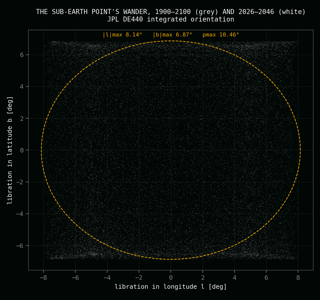
The shoulder in figures — twenty years of sky against the real skyline, the full sky window, and the wobble that drives it all.
In plain language
What this site actually is
The EXAX project aims to place a single camera on the surface of the Moon and point it at Earth — a fixed eye on solid ground that keeps the planet in frame for years on end. The brief behind this page is exact: find a place where the lunar horizon regularly cuts across the bright disk — two worlds in one photograph — but where Earth never sinks more than half below that horizon. Not in the deepest bow of the deepest year. Not ever.
The south's answer is a mountain NASA already knows by name. Mons Mouton is the highest massif of the lunar south, home to two Artemis III candidate landing regions; the VIPER ice rover was aimed at its plateau, and the IM-2 Athena lander reached its flank in March 2025. But the famous parts of the mountain give the wrong sky: on the central plateau Earth never touches the horizon at all — majestic and motionless — while on the southern plateau it disappears completely for days at a time. The picture this project wants — ocean, cloud and Moon rock in one frame — lives between those extremes, on the northeastern shoulder described above.
The numbers come from JPL's DE440 planetary ephemeris — the one NASA missions navigate by — turned into local sky tracks for this exact spot, then tested hour by hour against a horizon ray-marched out of NASA's LOLA laser elevation maps; the full method, cross-checks and source record are on the validation page. Because a lander never touches down exactly on its marker, the guarantee was re-verified at sixteen surrounding positions across a 640-metre pad. The remaining step before a camera stands here is a metre-class survey of the northwestern skyline, to fix each bow's depth to the last fraction of a degree.
Questions
What you need to know about this southern location.
Why this exact position?
Because the mountain's sky changes with every kilometre of position, and this is the one shoulder found where the horizon takes a real bite of Earth nearly every month while the half-set guarantee still holds: the centre stays at least 0.24° above the skyline in every tested year from 1900 to 2100, at every position within a 640-metre landing pad.
Why is height the trick?
At 84.6°S on level ground, Earth would regularly disappear completely. From 6,448 metres the visible horizon drops 3.3° below level — and Earth, riding low, bows into that hollow instead of behind it. Every kilometre of height buys roughly two degrees of latitude; this site spends six and a half kilometres to stand deep in the polar south and still keep more than half of Earth up, always.
How often are both worlds in one frame?
For 7.5% of all hours — about one hour in thirteen, the strongest both-worlds share of any site that passes the half-set rule. Thirteen bows a year on the Moon's 27.21-day nod, each lasting around 51 hours, their depth breathing over 173 days, the full pattern repeating every 18.6 years.
Where does Earth stand in the sky here?
Low in the northwest, drifting through a 17°-wide window between azimuths 314° and 331°, never higher than 11.3° — against a skyline that sits 3.3° below level. The disk is 1.8–2.0° wide. The whole 18.6-year wander fits a fixed lens; nothing ever needs to track.
Is this mountain proven ground?
As proven as the lunar south gets. Mons Mouton carries two Artemis III candidate landing regions; NASA's VIPER rover was targeted at it; the IM-2 Athena lander reached its flank in March 2025. Even its small craters are named — Floss sits 16 km from the site, Masina, Jaci and Dawa on the plateau to the south. The published JPL full-cycle study that mapped its central plateau anchors this page's comparison table.
What is the remaining step before installation?
A metre-class survey of the northwestern skyline. The audit's horizon comes from laser maps at 80–240-metre resolution — good enough to certify the guarantee with margin, but each bow's exact depth still moves by real fractions of a degree with every metre of plateau rim. Extracting a centimetre-grade horizon from orbital stereo imagery is the next phase.
Sources and related pages
The full validation — ephemeris basis, the laser-altimetry horizon method, the pad-robustness test, published-study cross-checks, and the complete source record — is on the validation page and in the downloadable science dossier.